
搜索结果: 1-15 共查到“工学 GF-2”相关记录54条 . 查询时间(0.143 秒)
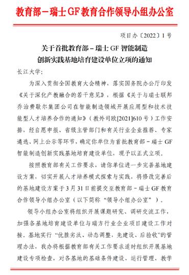
近日,教育部高校毕业生就业协会正式发布首批中瑞智能制造创新实践基地培育建设单位名单,经前期申报、省级主管部门和有关行业企业推荐、专家遴选、网上公示等环节,长江大学机械工程学院申报的教育部-瑞士GF智能制造创新实践基地培育建设单位予以正式立项。
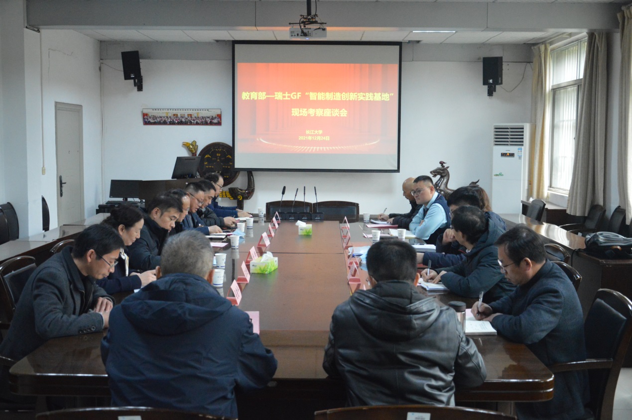
2021年12月24日,在长江大学机械学院7-305会议室,长江大学召开教育部―瑞士GF智能制造创新实践基地建设座谈交流会。教育部―瑞士GF教育合作项目办公室副主任王庆梅,办公室成员朱忠谊、潘冀黔,副校长周思柱,教务处、国资处、机械学院、电信学院负责人出席会议。会议由国际交流与合作处处长曾亚军主持。
面向GF-1 WFV数据的闽江下游叶绿素a反演模型研究
叶绿素a 随机森林 BP神经网络 GF-1 WFV
2020/1/6
叶绿素a浓度是可直接遥感反演的重要水质参数之一,常用来评价水体的富营养化程度.为建立适合于闽江下游叶绿素a浓度的反演模型,利用地面采样数据,结合GF-1 WFV光谱响应函数,选用多元回归、BP神经网络和随机森林方法,构建了叶绿素a浓度反演模型;并根据验证数据与实测值之间的决定系数(R2)、均方根误差(RMSE)和平均相对误差对模型反演结果进行了比较.结果发现,随机森林模型的R2为0.895,RMS...
国产GF-6号卫星交付使用、农业遥感卫星成为现实(图)
国产GF-6号卫星 农业 遥感卫星
2019/3/27
2019年3月21日上午国家国防科技工业局、国家航天局组织召开了高分五号和高分六号卫星的交付仪式。农业农村部总畜牧师马有祥,发展规划司副司长时以群和中国农业科学院农业资源与农业区划研究所所长周清波等作为农业行业用户出席了此次会议。高分六号卫星于2018年6月2日成功发射,是我国首颗设置红边谱段和采用国产CMOS成像器件的多光谱遥感卫星;以单台相机体制实现了超大视场成像,并在轨与高分一号卫星的组网运...
A NOVEL TWO-COMPONENT DECOMPOSITION FOR CO-POLAR CHANNELS OF GF-3 QUAD-POL DATA
GF-3 satellite, Model-based decomposition, Two-component decomposition, Co-polar data, PolSAR
2018/5/14
Polarimetric target decomposition theory is the most dynamic and exploratory research area in the field of PolSAR. But most methods of target decomposition are based on fully polarized data (quad pol)...
STRUCTURAL INFORMATION DETECTION BASED FILTER FOR GF-3 SAR IMAGES
GF-3 SAR images despeckling filter adaptive windowing structural information
2018/5/15
GF-3 satellite with high resolution, large swath, multi-imaging mode, long service life and other characteristics, can achieve allweather and all day monitoring for global land and ocean. It has becom...
GF-3 SAR IMAGE DESPECKLING BASED ON THE IMPROVED NON-LOCAL MEANS USING NON-SUBSAMPLED SHEARLET TRANSFORM
GF-3 SAR non-subsampled Shearlet transform image despeckling improved Non-Local Means
2018/5/15
GF-3 synthetic aperture radar (SAR) images are rich in information and have obvious sparse features. However, the speckle appears in the GF-3 SAR images due to the coherent imaging system and it hinde...
POLARIMETRIC CALIBRATION AND ASSESSMENT OF GF-3 IMAGES IN STEPPE
Polarimetric calibration PolSAR GF- image quality reflection symmetry
2018/5/11
The GaoFen-3 (GF-3) satellite is the first fully polarimetric synthetic aperture radar (PolSAR) satellite in China. It has three fully polarimetric imaging modes and is available for many applications...
EXTRACTION AND ANALYSIS OF MAJOR AUTUMN CROPS IN JINGXIAN COUNTY BASED ON MULTI - TEMPORAL GF - 1 REMOTE SENSING IMAGE AND OBJECT-ORIENTED
Remote Sensing Autumn Crops Object-oriented Information Extraction Phenological Characteristics
2018/5/15
The purpose of this paper is to provide decision support for the adjustment and optimization of crop planting structure in Jingxian County. The object-oriented information extraction method is used to...
Starting from the lunar observation requirements of the GF-4 satellite, the main index such as the resolution, the imaging field, the reflect radiance and the imaging integration time are analyzed com...
ANALYSIS AND APPLICATION OF LINEAMENTS EXTRACTION USING GF-1 SATELLITE IMAGES IN LOESS COVERED
Geological lineaments Remote Sensing GF-1 satellite images Hough Transform Edge detection
2018/5/14
Faults, folds and other tectonics regions belong to the weak areas of geology, will form linear geomorphology as a result of erosion, which appears as lineaments on the earth surface. Lineaments contr...
A CLOUD BOUNDARY DETECTION SCHEME COMBINED WITH ASLIC AND CNN USING ZY-3, GF-1/2 SATELLITE IMAGERY
CNN ASLIC GF-1/2 ZY-3 Imaging platforms
2018/5/14
Remote sensing optical image cloud detection is one of the most important problems in remote sensing data processing. Aiming at the information loss caused by cloud cover, a cloud detection method bas...
REMOTE SENSING MONITORING OF WETLAND OF SANYA AND LINGSHUI IN HAINAN PROVINCE, BASED ON GF DATA
Remote Sensing Wetland Monitoring GF Data Natural Wetland Constructed Wetland Hainan Province
2018/5/14
Wetland is an important land and natural resources with many functions. It is closely related to the survival, reproduction and development of human beings, as well as one of the most important living...
URBAN BUILT-UP AREA EXTRACTION AND APPLICATION BASED ON GF-2 SATELLITE DATA
GF-2 satellite object-oriented method built-up area Shennongjia
2018/5/16
GF-2 satellite was launched in China on August 19, 2014. It has wide potential applications with the spatial resolution of around 1 meter. In this paper, urban built-up area was extracted and classifi...