
搜索结果: 1-15 共查到“工学 Satellite”相关记录766条 . 查询时间(0.166 秒)
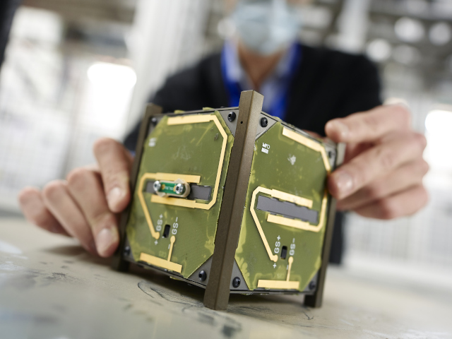
On 13 July, CELESTA will be launched into space: this microsatellite is the first space mission driven by CERN, in collaboration with the University of Montpellier and the European Space Agency (ESA).
A new program provides undergraduates, graduate students and postdoctoral researchers from the College of Engineering and the College of Arts and Sciences with hands-on experience in developing innova...
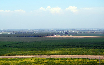
Researchers use satellite imaging to map groundwater use in California's Central Valley(图)
satellite imaging map groundwater California Central Valley
2020/10/16
Researchers at the University of California, San Diego report a new way to improve groundwater monitoring by using a remote sensing technology, known as InSAR (interferometric synthetic aper...

Satellite constellations harvest energy for near-total global coverage(图)
Satelliteconstellations harvest energy global coverage
2020/1/19
Think of it as a celestial parlor game: What is the minimum number of satellites needed to see every point on Earth? And how might those satellites stay in orbit and maintain 24/7 coverage while conte...
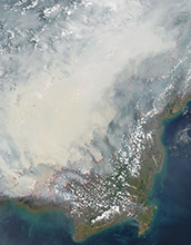
Satellite data can reveal fire susceptibility in peatlands(图)
Satellite data fire susceptibility peatlands
2019/10/18
When large areas of carbon-rich soil catch fire, the blaze emits massive amounts of carbon into the atmosphere and creates a thick haze. These blazes can usher in long-term climate impacts that affect...
CLASSIFICATION OF THE STRUCTURE OF CITIES THROUGH MID-RESOLUTION SATELLITE IMAGERY AND PATCH BASED NEURAL NETWORKS
Convolutional Neural Networks (CNN) Autoencoders Sentinel 2B Indian Cities
2019/2/28
The studies in the classification of the urban spatial structure have been essential in deriving insights into the land cover and the built typology which helped in the estimation of energy consumptio...
EXTRACTION OF BLUE ICE AREA USING ALBEDO VALUE DERIVED FROM LANDSAT-8 SATELLITE DATA
Blue Ice Landsat-8 Albedo Polar record Glacier Image Processing
2019/2/28
Blue Ice Areas (BIAs) or bare ice areas are zones of glacier where surface mass balance is negative, sublimation forms the major ablation process and surface albedo is relatively small. Exceptionally ...
MULTI-SATELLITE OBSERVATION OF MEGH CYCLONE
Cyclone Megh RISAT-1 Synthetic aperture radar cloud microphysics Wind speed
2019/2/28
Cyclone Megh, a category-3 (Saffir-Simpson scale) cyclonic storm is regarded as the worst tropical cyclone to ever strike Yemen’s island of Socotra. In this paper, we aim to investigate the wind struc...
BUILDING FOOTPRINT EXTRACTION FROM HIGH RESOLUTION SATELLITE IMAGERY USING SEGMENTATION
Segmentation Building Extraction Multi-Resolution Algorithm Rule-Based Feature Extraction High Resolution Satellite Imagery
2019/2/27
Identification and mapping of urban features such as buildings and roads are an important task for cartographers and urban planners. High resolution satellite imagery supports the efficient extraction...
A WEB-BASED VIRTUAL LABORATORY FOR SATELLITE IMAGE PROCESSING AND ANALYSIS
Education Satellite Image Processing E-Learning Tool Web-based Virtual Laboratory
2019/2/27
With continuous increase in the utilization of satellite images in various engineering and science fields, it is imperative to equip students with additional educational aid in subject of satellite im...
ROAD NETWORK IDENTIFICATION AND EXTRACTION IN SATELLITE IMAGERY USING OTSU'S METHOD AND CONNECTED COMPONENT ANALYSIS
Road identification road extraction Otsu's method connected component analysis morphological operations
2019/2/27
As the high resolution satellite images have become easily available, this has motivated researchers for searching advanced methods for object detection and extraction from satellite images. Roads are...
EXTRACTION OF BUILT-UP AREA USING HIGH RESOLUTION SENTINEL-2A AND GOOGLE SATELLITE IMAGERY
Built-up area Extraction Normalized Difference Index High Resolution Satellite Imagery Sentinel-2A Google Satellite Imagery
2018/11/9
Accurate information about the built-up area in a city or town is essential for urban planners for proper planning of urban infrastructure facilities and other basic amenities. The normalized differen...
ASSESSMENT OF SEASONAL VARIABILITY FOR WIND SPEED AND SIGNIFICANT WAVE HEIGHT USING SATELLITE ALTIMETER OVER MALAYSIAN SEAS
Wind speed significant wave height Seasonal variations Satellite Altimeter Radar Altimeter Database System Monsoons
2018/11/9
Malaysia is located in the equatorial region and experienced climate hot, humid and rainy throughout the year. These have brought four monsoon seasons to Malaysia which can be categorised as Northeast...
INTEGRATION OF TREE DATABASE DERIVED FROM SATELLITE IMAGERY AND LIDAR POINT CLOUD DATA
Tree Crown Identification and Delineation Canopy Height Model Lidar Point Cloud Camera Model
2018/11/9
3D tree database provides essential information of tree species abundance, spatial distribution and tree height for forest mapping, sustainable urban planning and 3D city modelling. Fusion of passive ...
IMAGE QUALITY ASSESSMENT OF HIGH-RESOLUTION SATELLITE IMAGES WITH MTF-BASED FUZZY COMPREHENSIVE EVALUATION METHOD
Image Quality Assessment High-resolution Satellite Images MTF Fuzzy Comprehensive Evaluation
2018/5/15
A Modulation Transfer Function (MTF)-based fuzzy comprehensive evaluation method was proposed in this paper for the purpose of evaluating high-resolution satellite image quality. To establish the fact...