
搜索结果: 1-15 共查到“Geomorphology”相关记录19条 . 查询时间(0.14 秒)
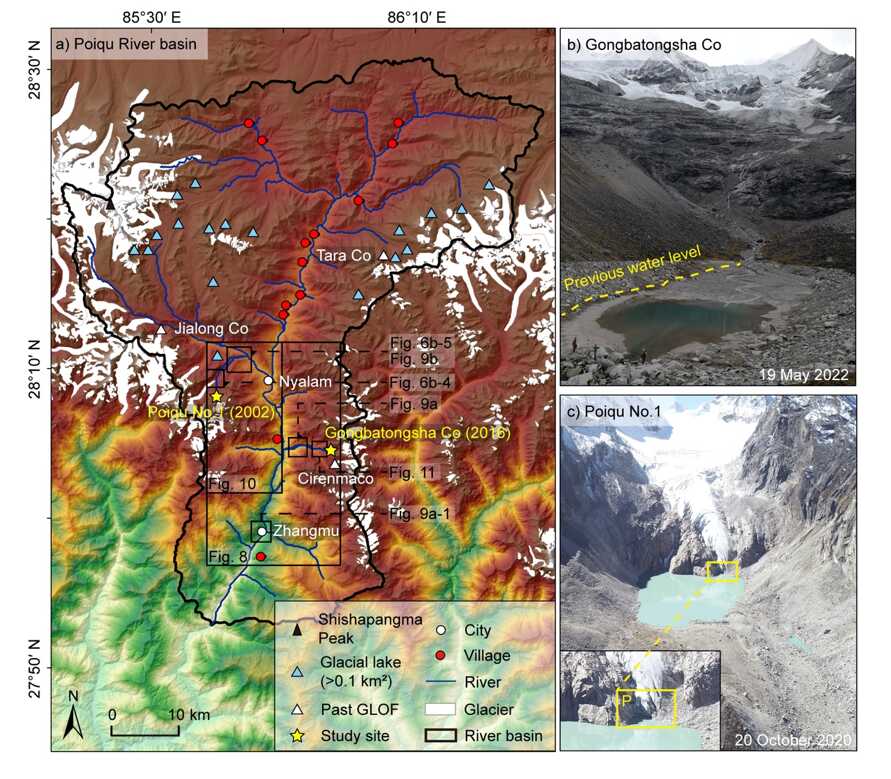
冰湖溃决洪水(glacial lake outburst flood, GLOF)是一种由冰湖突然大量排水形成的灾难性洪水,是高山地区的主要自然灾害之一,具有突发性强、海拔落差大等特点,严重威胁着下游人民的生命和财产安全。如何阐明冰湖溃决洪水事件的触发因素,重建和预测冰湖溃决洪水灾害,对下游地区防灾减灾管理至关重要。

中国地质大学(武汉)海洋学院王星星副教授在国际著名科学期刊《Geomorphology》发表论文――构造与海洋过程对南海东沙陆坡树枝型峡谷体系的控制(图)
王星星 Geomorphology 海洋地质灾害 树枝型海底峡谷
2022/9/16
海底峡谷是大陆边缘重要的地貌单元,对沉积物“源―汇”过程及其相关能源资源、海底生态系统和海洋地质灾害等均具有重要影响。根据地貌特征,海底峡谷可分为单支型海底峡谷与树枝型海底峡谷体系。相较于单支型海底峡谷,树枝型海底峡谷体系多分布于构造活跃陆缘,具有活动性强和覆盖面积广等特征,因此可向深海输运更为丰富的陆源碎屑及有机质,为深海油气和天然气水合物聚集成藏提供充足的物质基础和储集空间,同时对深海碳汇过程...
中国科学院青海盐湖研究所青海盐湖所盐湖地质与环境实验室凌智永博士在《Geomorphology》发表青藏科考成果(图)
凌智永 博士 青藏 科考成果 地球表层系统 人类活动 环境演化
2020/3/2
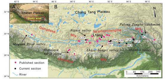
近日,青海盐湖所盐湖地质与环境实验室助理研究员凌智永博士在《Geomorphology》上发表了题为“Spatial-temporal differentiation of eolian sediments in the Yarlung Tsangpo catchment, Tibetan Plateau, and response to global climate change since t...
This year's Annual Meeting of the British Society for Geomorphology (BSG) will be held at Plymouth University (UK) from the 5th -7th September 2016 and we welcome oral or poster presentations on any ...
RESEARCH ON THE INFORMATION EXTRACTION OF PERIGLACIAL GEOMORPHOLOGY IN QINGHAI-TIBET PLATEAU
Image Interpretation Digital Elevation Models (DEM) Image Understanding Feature Extraction Geomorphology Qinghai-Tibet Plateau
2015/12/29
Takes Qinghai-Tibet Plateau as a research field, this paper based on the models and algorithms, completes the numerical information extraction of periglacial geomorphology distribution by using SRTM-D...
Geomorphology of the Gubbio Basin (Central Italy):understanding the active tectonics and earthquake potential
tectonic geomorphology normal fault seismogenic sources Umbria-Marche Apennines-29 April 1984 Gubbio earthquake
2015/9/16
The Gubbio Basin is a 22 km long, 4 km wide depression located within the North-Central Apennines fold-andthrust belt. The basin is bounded to the east by the Gubbio Fault, a W-dipping, normal fault d...
Modeling Hydrological Response of Indus Basin as a Function of Geomorphology and Land Cover Change
SWAT model DEM Morphometry
2015/8/28
Geomorphological characteristics of a basin represent physical and morphological attributes that are employed in
synthesizing its hydrological response. These attributes have direct bearing on the hy...
The Geomorphology of the Great Barrier Reef:Development,Diversity,and Change
Great Barrier Reef Development Diversity Change
2015/7/20
The Geomorphology of the Great Barrier Reef by David Hopley, Scott G. Smithers, and Kevin E. Parnell was preceded 25 years ago by Hopley's landmark book on the same topic. The first book filled a void...
GEOMORPHOLOGY OF THE BLUE NILE BY REMOTE SENSING.
Geology and Geomorphology of the Manipur Valley Using Digitally Enhanced Satellite Image and SRTM DEM in the Eastern Himalaya, India
Imphal Valley Remote Sensing and Geographical Information Systems
2013/3/11
Landsat ETM+ data and SRTM DEM data were used to delineate the geological, structural and geomorphological features in the intermontane Imphal Valley in Manipur, India. This area has simple geology, s...
YANGON RIVER GEOMORPHOLOGY IDENTIFICATION AND ITS ENVIROMENTAL IMAPACTS ANALSYSI BY OPTICAL AND RADAR SENSING TECHNIQUES
Fluvial Sedimentology LULC Hydrologic process Environmental impacts
2014/4/29
The Yangon river, also known as the Rangoon river, is about 40 km long (25miles), and flows from southern Myanmar as an outlet of the Irrawaddy (Ayeyarwady) river into the Ayeyarwady delta. The Yangon...
An examination of the coastal geomorphology of bays along the Otago coastline, SE New Zealand, has identified a geomorphology consistent with tsunami inundation. A tsunami geomorphology consisting of ...
An examination of the coastal geomorphology of bays along the Otago coastline, SE New Zealand, has identified a geomorphology consistent with tsunami inundation. A tsunami geomorphology consisting of ...
In mountainous landscapes the organization of fluvial networks is not random. Valleys tend to be evenly spaced1 and, at the front of mountain ranges, the spacing of the drainage basin outlets is a dir...
Evolutionary geomorphology:thresholds and nonlinearity in landform response to environmental change
Evolutionary geomorphology environmental change
2009/5/15
Geomorphic systems are typically nonlinear, owing largely to their threshold-dominated nature (but due to other factors as well). Nonlinear geomorphic systems may exhibit complex behaviors not possibl...