
�������: 1-15 ���鵽��Landslide����ؼ�¼187�� . ��ѯʱ��(0.078 ��)
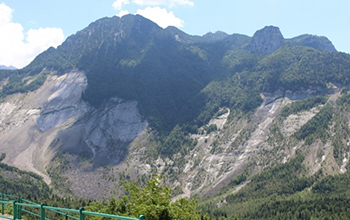
Taking a landslide's temperature to avert catastrophe��ͼ��
Taking landslide temperature avert catastrophe
2020/7/3
Engineers at Duke University have developed a comprehensive new model of deep-seated landslides, and demonstrated that it can accurately recreate the dynamics of historic and current landsli...
LANDSLIDE HAZARD ZONATION MAPPING OF CHAMOLI LANDSLIDES IN REMOTE SENSING AND GIS ENVIRONMENT
Landslides Chamoli Remote Sensing Hazard, Himalaya
2019/2/27
Landslides are very common problem in hilly terrain. Chamoli region of Himalaya is highest sensitive zone of the landslide hazards. The purpose of Chamoli landslide study, to observe the important ter...
LANDSLIDE HAZARD ZONATION IN AND AROUND KEDARNATH REGION AND ITS VALIDATION BASED ON REAL TIME KEDARNATH DISASTER USING GEOSPATIAL TECHNIQUES
Landslide Hazard Zonation GIS Orthorectification Drainage Density Geomorphology
2019/2/28
Landslides are one of the frequently happening disasters in this hilly state of Uttarakhand which accounts to the loss of lives and property every year especially during the rainy season which lead to...
ASSIMILATING GEOSPATIAL METAMODEL AND INVENTORY MAPPING FOR NON-STRUCTURAL MITIGATION OF LANDSLIDE
metamodel, geospatial metamodel disaster management landslide landslide inventory mapping
2018/11/9
In Malaysia, issues related to disaster management are always given attention in society and by the responsible parties. However, in general, citizen do not think of the consequential impact of disast...
GEOSPATIAL APPROACH FOR LANDSLIDE ACTIVITY ASSESSMENT AND MAPPING BASED ON VEGETATION ANOMALIES
Tropical rain forest Landslide activity egetation anomalies
2018/11/9
Remote sensing has been widely used for landslide inventory mapping and monitoring. Landslide activity is one of the important parameters for landslide inventory and it can be strongly related to vege...
EVALUATING THE PERFORMANCE OF TERRESTRIAL LASER SCANNING FOR LANDSLIDE MONITORING
landslide monitoring terrestrial laser scanning scanning resolutions geodetic method deviation maps
2018/11/8
Nowadays, Terrestrial Laser Scanning (TLS) technology is gaining popularity in monitoring and predicting the movement of landslide due to the capability of high-speed data capture without requiring a ...
COMPARING THE PERFORMANCE OF POINT CLOUD REGISTRATION METHODS FOR LANDSLIDE MONITORING USING MOBILE LASER SCANNING DATA
point clouds, registration methods landslide monitoring mobile laser scanning deviation maps
2018/11/8
The aim of the research is to evaluate the performance of the point cloud registration methods using mobile laser scanning data. The point cloud registration methods involved in this research are matc...
THE LANDSLIDE HAZARD MAP OF BOGOTA AN UPDATING
Landslides Bogota GRASS GIS Risk management Modelling Model Builder
2018/11/8
A land management plan (Plan de Ordenamiento Territorial, POT) is an instrument for planning the land-use of a territory considering physical, social and economic aspects. In the frame of the POT��s up...
HAZARD ASSESSMENT OF LANDSLIDE DISASTER IN FUJIAN PROVINCE BASED ON FUZZY MATHEMATICS
Landslide Hazard Assessment Fuzzy Mathematics
2018/5/15
Landslide disasters are the most frequent geological disasters in Fujian Province. They are also the type of geological disasters that cause the most serious economic and population losses each year. ...
THE TRANSMISSION CHANNEL TOWER IDENTIFICATION AND LANDSLIDE DISASTER MONITORING BASED ON INSAR
Transmission Channel Transmission Tower Identification InSAR Time Series D-InSAR Landslide Monitoring
2018/5/14
The transmission distance of transmission lines is long, the line affected by the diversity of climate and topography of the corridors of transmission lines, differences in regional geological structu...
POTENTIAL LANDSLIDE EARLY DETECTION NEAR WENCHUAN BY A QUALITATIVELY MULTI-BASELINE DINSAR METHOD
Landslide Early detection DInSAR Sentinel-1 Wenchuan
2018/5/11
Early detection of landslides is important for disaster prevention, which was still very hard work with traditional surveying methods. Interferometric Synthetic Aperture Radar (InSAR) technology provi...
RAPID EXTRACTION OF LANDSLIDE AND SPATIAL DISTRIBUTION ANALYSIS AFTER JIUZHAIGOU Ms7.0 EARTHQUAKE BASED ON UAV IMAGES
Jiuzhaigou earthquake UAV object-oriented landslide extraction spatial distribution analysis
2018/5/14
Jiuzhaigou earthquake led to the collapse of the mountains and formed lots of landslides in Jiuzhaigou scenic spot and surrounding roads which caused road blockage and serious ecological damage. Due t...
LANDSLIDE INVENTORY MAPPING FROM BITEMPORAL 10 m SENTINEL-2 IMAGES USING CHANGE DETECTION BASED MARKOV RANDOM FIELD
Landslide Inventory Mapping Change Detection Normalized Difference Vegetation Index Principal Component Analysis Markov Random Field Sentinel-2 Images
2018/5/15
Landslide inventory mapping is essential for hazard assessment and mitigation. In most previous studies, landslide mapping was achieved by visual interpretation of aerial photos and remote sensing ima...
TWO-DIMENSIONAL LOESS LANDSLIDE DEFORMATION MONITORING WITH MULTIDIMENSIONAL SMALL BASELINE SUBSET (MSBAS) �C A CASE STUDY OF XINYUAN No.2 LANDSLIDE, GANSU, CHINA
Landslide monitoring InSAR MSBAS TerraSAR-X Retrogressive failure
2018/5/16
The deformation monitoring of active landslides is of great importance for the safety of human lives and properties. And twodimensional deformation result can give us more thoughts on the landslide ty...
MT-INSAR LANDSLIDE MONITORING WITH THE AID OF HOMOGENEOUS PIXELS FILTER
Goldstein filter Homogeneous pixels filter TerraSAR-X SBAS Landslide monitoring
2018/5/15
SAR interferograms are often contaminated by random noises related to temporal decorrelation, geometrical decorrelation and thermal noises, which makes the fringes obscured and greatly decreases the d...
�й��о����������а�-��
- ���ڼ���...
�й�ѧ���ڿ����а�-��
- ���ڼ���...
�����ѧ���л������а�-��
- ���ڼ���...
�й���ѧ���а�-��
- ���ڼ���...
�ˡ���-ƪ
- ���ڼ���...
�Ρ���-ƪ
- ���ڼ���...
��������-ƪ
- ���ڼ���...
�������� -ƪ
- ���ڼ���...
֪ʶҪ��-ƪ
- ���ڼ���...
���ʶ�̬-ƪ
- ���ڼ���...
��������-ƪ
- ���ڼ���...
ѧ��ָ��-ƪ
- ���ڼ���...
ѧ��վ��-ƪ
- ���ڼ���...