
�������: 1-15 ���鵽������ѧ���� environment����ؼ�¼153�� . ��ѯʱ��(0.052 ��)
Remote Sensing of Environment�����й���ѧԺˮ����ˮ�������о�����Ф���о�Ա�Ŷ��չ��յ�Ҷ����ӫ���о�������չ��ͼ��
��Ф�� �չ��յ� Ҷ����ӫ�� SIF GPP
2022/6/8
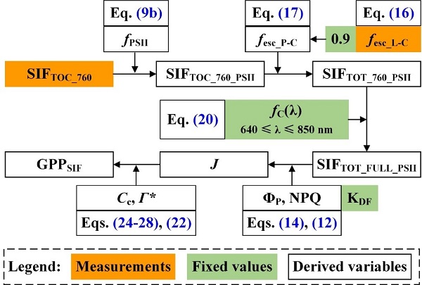
���գ��й���ѧԺˮ����ˮ�������о�����Ф���о�Ա�Ŷ�������ũ�ֿƼ���ѧ������ԭ������ʴ�뺵��ũҵ�����ص�ʵ����Ϊ��һ��λ�ڹ���ң�������ڿ�Remote Sensing of Environment��G1�ڿ�����������Ϊ��Direct estimation of photosynthetic CO2 assimilation from solar-induced chlorophyll fluo...

ͬ�ô�ѧ����������ϢѧԺ��Ⱥ�����ڿ����鱾������ң�������ڿ���Remote Sensing of Environment���������ģ�Blocks-removed spatial unmixing for downscaling MODIS images��ͼ��
ͬ�ô�ѧ ����������ϢѧԺ ��Ⱥ�� ���� ������ ң������ �����ڿ�
2021/3/18
���գ�ͬ�ô�ѧ����������ϢѧԺ��Ⱥ�����ڿ�������ң�������ڿ���Remote Sensing of Environment��������1ƪ���ġ����о��ܵ�������Ȼ������Ŀ��41971297��������
�й��ϼ�����о�������Сƽ�����ŶӺ���ң���о��ɹ��ڡ�Remote Sensing of Environment������
�й��ϼ�����о����� ��Сƽ ���� ����ң�� �о��ɹ� ��Remote Sensing of Environment��
2020/9/7
ͨ�����߷ֱ��ʵ��Ⱥ���Ӱ�������ܷ��ֱ�����������Щ��Ȥ���ԣ����գ������IJ�ʿ������Ϊ��һ���ߣ����˸�����ΪͨѶ���ߵ��о������ڡ�����ң�С����������о�����Landsat 8 TIRS�Ⱥ���Ӱ����֤�˼��־�����¶ȷ����㷨�ڱ�����������ľ��ȣ����Ա���ˮ���ͺ�����Ե�����¶����������˷�����
LANDSLIDE HAZARD ZONATION MAPPING OF CHAMOLI LANDSLIDES IN REMOTE SENSING AND GIS ENVIRONMENT
Landslides Chamoli Remote Sensing Hazard, Himalaya
2019/2/27
Landslides are very common problem in hilly terrain. Chamoli region of Himalaya is highest sensitive zone of the landslide hazards. The purpose of Chamoli landslide study, to observe the important ter...
LINKDALE: A LIGHTWEIGHT LEARNING ENVIRONMENT FOR (GEOSPATIAL) LINKED DATA
Linked Data education earning environment reactjs visual linking
2018/11/8
Modern software tools for managing Linked Data are often designed for skilled users. Therefore, they cannot be used for education purposes because they require substantial a priori knowledge about the...
IMPLEMENTATION OF A COMPREHENSIVE AND EFFECTIVE GEOPROCESSING WORKFLOW ENVIRONMENT
Workflow Geoprocessing Remote Sensing Earth Observation
2018/11/8
Many projects and research efforts implement geo-information (GI) workflows, ranging from very basic ones to complicated software processing chains. The creation of these workflows normally needs cons...
ORTHORECTIFICATION OF A LARGE DATASET OF HISTORICAL AERIAL IMAGES: PROCEDURE AND PRECISION ASSESSMENT IN AN OPEN SOURCE ENVIRONMENT
image orthorectification GIS historical aerial images
2018/11/8
The availability of data time series spanning a long period is crucial for landscape change analysis. A suitable dataset, both in terms of time span and information content, must be available for the ...
���ӿƼ���ѧ��Դ�뻷��ѧԺ��ʿ����Remote Sensing of Environment�������ģ�ͼ��
���ӿƼ���ѧ��Դ�뻷��ѧԺ ��ʿ�� Remote Sensing of Environment ��ң��
2018/4/12
���գ���Դ�뻷��ѧԺ����ң���ŶӲ�ʿ����չâ��ң�������ڿ���Remote Sensing of Environment������ѧ�����ġ�The impacts of spatial baseline on forest canopy height model and digital terrain model retrieval using P-band PolInSAR data������չâΪ��...
CHALLENGES AND OPPORTUNITIES: ONE STOP PROCESSING OF AUTOMATIC LARGE-SCALE BASE MAP PRODUCTION USING AIRBORNE LIDAR DATA WITHIN GIS ENVIRONMENT. CASE STUDY: MAKASSAR CITY, INDONESIA
Automation LiDAR Processing Base Map Production GIS Accuracy Assessment
2017/7/12
LiDAR data acquisition is recognized as one of the fastest solutions to provide basis data for large-scale topographical base maps worldwide. Automatic LiDAR processing is believed one possible scheme...
STRUCTURE-FROM-MOTION FOR CALIBRATION OF A VEHICLE CAMERA SYSTEM WITH NON-OVERLAPPING FIELDS-OF-VIEW IN AN URBAN ENVIRONMENT
Vehicle cameras camera calibration structure from motion bundle adjustment
2017/7/12
Vehicle environment cameras observing traffic participants in the area around a car and interior cameras observing the car driver are important data sources for driver intention recognition algorithms...
GEOREFERENCING IN GNSS-CHALLENGED ENVIRONMENT: INTEGRATING UWB AND IMU TECHNOLOGIES
Ultra-wide band GNSS-denied positioning UXO mapping
2017/7/12
Acquiring geospatial data in GNSS compromised environments remains a problem in mapping and positioning in general. Urban canyons, heavily vegetated areas, indoor environments represent different leve...
CULTURAL HERITAGE DOCUMENTATION IN SIS ENVIRONMENT: AN APPLICATION FOR "PORTA SIRENA" IN THE ARCHAEOLOGICAL SITE OF PAESTUM
SIS GIS Close Range Photogrammetry Cultural Heritage Point Clouds
2017/6/20
The Heritage Documentation allows the monitoring, maintenance and conservation by the most recent, efficient investigation techniques and storage of data. A key role in Heritage Documentation is repre...
PROCESSING BIG REMOTE SENSING DATA FOR FAST FLOOD DETECTION IN A DISTRIBUTED COMPUTING ENVIRONMENT
Distributed Computing Geospatial Big Data Cloud Computing Fast Flood detection Big Earth Observation Data
2017/8/10
The Earth observation (EO) missions of the space agencies and space industry (ESA, NASA, national and commercial companies) are evolving as never before. These missions aim to develop and launch next-...
MODELLING AND ACCURACY IN A BIM ENVIRONMENT FOR PLANNED CONSERVATION: THE APARTMENT OF TROIA OF GIULIO ROMANO
BIM, accuracy 3D modelling HBIM planned conservation
2017/4/5
Modeling of Cultural Heritage in a BIM environment, and in general of existing buildings, requires special attention because there are two diametrically opposed possibilities. On the one hand the atte...
EARTH OBSERVATION-SUPPORTED SERVICE PLATFORM FOR THE DEVELOPMENT AND PROVISION OF THEMATIC INFORMATION ON THE BUILT ENVIRONMENT�CTHE TEP-URBAN PROJECT
Service platform participatory urban monitoring earth observation decision support
2016/12/1
The Sentinel fleet will provide a so-far unique coverage with Earth observation data and therewith new opportunities for the implementation of methodologies to generate innovative geo-information prod...
�й��о����������а�-��
- ���ڼ���...
�й�ѧ���ڿ����а�-��
- ���ڼ���...
�����ѧ���л������а�-��
- ���ڼ���...
�й���ѧ���а�-��
- ���ڼ���...
�ˡ���-ƪ
- ���ڼ���...
�Ρ���-ƪ
- ���ڼ���...
��������-ƪ
- ���ڼ���...
�������� -ƪ
- ���ڼ���...
֪ʶҪ��-ƪ
- ���ڼ���...
���ʶ�̬-ƪ
- ���ڼ���...
��������-ƪ
- ���ڼ���...
ѧ��ָ��-ƪ
- ���ڼ���...
ѧ��վ��-ƪ
- ���ڼ���...