
搜索结果: 1-15 共查到“摄影测量与遥感技术 MAP”相关记录94条 . 查询时间(0.149 秒)
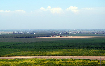
Researchers use satellite imaging to map groundwater use in California's Central Valley(图)
satellite imaging map groundwater California Central Valley
2020/10/16
Researchers at the University of California, San Diego report a new way to improve groundwater monitoring by using a remote sensing technology, known as InSAR (interferometric synthetic aper...
CHALLENGES AND OPPORTUNITIES: ONE STOP PROCESSING OF AUTOMATIC LARGE-SCALE BASE MAP PRODUCTION USING AIRBORNE LIDAR DATA WITHIN GIS ENVIRONMENT. CASE STUDY: MAKASSAR CITY, INDONESIA
Automation LiDAR Processing Base Map Production GIS Accuracy Assessment
2017/7/12
LiDAR data acquisition is recognized as one of the fastest solutions to provide basis data for large-scale topographical base maps worldwide. Automatic LiDAR processing is believed one possible scheme...
UNCERTAINTY ASSESSMENT AND WEIGHT MAP GENERATION FOR EFFICIENT FUSION OF TANDEM-X AND CARTOSAT-1 DEMS
Accuracy assessment Data fusion Predicted weight map Artificial Neural Network TanDEM-X DEM Cartosat-1 DEM
2017/7/13
Recently, with InSAR data provided by the German TanDEM-X mission, a new global, high-resolution Digital Elevation Model (DEM) has been produced by the German Aerospace Center (DLR) with unprecedented...
FEATURE ORIENTATION AND POSITIONAL ACCURACY ASSESSMENT OF DIGITAL ORTHOPHOTO AND LINE MAP FOR LARGE SCALE MAPPING: THE CASE STUDY ON BAHIR DAR TOWN, ETHIOPIA
Orthophoto Line map GPS data Positional Orientation Accuracy
2017/7/12
This study used in-situ GPS data to validate the accuracy of horizontal coordinates and orientation of linear features of orthophoto and line map for Bahir Dar city. GPS data is processed using GAMIT/...
ESTIMATION OF STAND HEIGHT AND FOREST VOLUME USING HIGH RESOLUTION STEREO PHOTOGRAPHY AND FOREST TYPE MAP
Stand Height Forest Volume normalized DSM Aerial Photo
2016/11/30
Traditional field methods for measuring tree heights are often too costly and time consuming. An alternative remote sensing approach is to measure tree heights from digital stereo photographs which is...
KINECT V2 AND RGB STEREO CAMERAS INTEGRATION FOR DEPTH MAP ENHANCEMENT
3D modelling real-time range cameras RGB stereo cameras sensor integration
2016/11/11
Today range cameras are widespread low-cost sensors based on two different principles of operation: we can distinguish between Structured Light (SL) range cameras (Kinect v1, Structure Sensor, ...) an...
THE CARTOGRAPHIC CONCEPT OF THE IMAGE MAP
Visualization image image map map content remote sensing
2016/11/8
Image maps have become very popular and frequently produced cartographical outputs during recent years. However, the unambiguous terminology, definitions, content and appearance specification have not...
In the process of map making, the attention is given to the resulting image map (to be accurate, readable, and suit the primary purpose) and its user aspects. Current cartography understands the user ...
OPEN STREET MAP DATA AS SOURCE FOR BUILT-UP AND URBAN AREAS ON GLOBAL SCALE
Built-up Areas Urban Areas Volunteered Geographic Information OpenStreetMap Spatial Data Processing
2016/11/8
Many types of applications require information about built-up areas and urban areas. Thus, there is a need for a global, vector-based, up-to-date, and free dataset of high resolution and accuracy. The...
CREATION OF A WEB MAP AND MOBILE APPLICATION BASED ON A PRINTED BOOK
GIS ArcGIS History Web Application Nazi Occupation 1938-1945 Protectorate of Bohemia and Moravia Book Conversion
2016/11/8
The project describes a process of conversion of printed books into a web map and mobile application. The goal of the project is to make spatial data in the book accessible to wide public using GIS es...
AUTOMATIC CONSTRUCTION OF WI-FI RADIO MAP USING SMARTPHONES
Indoor Localization Navigation Image Matching Radio Map
2016/11/8
Indoor positioning could provide interesting services and applications. As one of the most popular indoor positioning methods, location fingerprinting determines the location of mobile users by matchi...
GEOMETRIC CONTEXT AND ORIENTATION MAP COMBINATION FOR INDOOR CORRIDOR MODELING USING A SINGLE IMAGE
Indoor Model Reconstruction Geometric Context Hypothesis-Verification Scene Layout Parameterization
2016/11/8
Since people spend most of their time indoors, their indoor activities and related issues in health, security and energy consumption have to be understood. Hence, gathering and representing spatial in...
A MAP MASH-UP APPLICATION: INVESTIGATION THE TEMPORAL EFFECTS OF CLIMATE CHANGE ON SALT LAKE BASIN
Konya Closed Basin Standardized Precipitation Index Google API NDVI Mash-Up
2016/11/8
The main purpose of this paper is to investigate climate change effects that have been occurred at the beginning of the twenty-first century at the Konya Closed Basin (KCB) located in the semi-arid ce...
DESIGN AND CONSTRUCTION OF MASSIVE DIGITAL ORTHOPHOTO MAP DATABASE IN CHINA
Digital Orthophoto Map DOM Image Massive data Database Design Construction
2016/11/8
Digital orthophoto maps have great advantages of high precision, plentiful information, fine intuition and visualization and convenient acquisition, as one of the most important part of national spati...
CLASSIFICATION OF LIDAR DATA FOR GENERATING A HIGH-PRECISION ROADWAY MAP
Lidar Feature extraction Machine learning Classification Mobile mapping
2016/7/27
Generating of a highly precise map grows up with development of autonomous driving vehicles. The highly precise map includes a precision of centimetres level unlike an existing commercial map with the...