
搜索结果: 1-15 共查到“测绘科学技术 MODIS”相关记录150条 . 查询时间(0.069 秒)

同济大学测绘与地理信息学院王群明教授课题组本科生在遥感领域顶级期刊《Remote Sensing of Environment》发表论文:Blocks-removed spatial unmixing for downscaling MODIS images(图)
同济大学 测绘与地理信息学院 王群明 教授 课题组 遥感领域 顶级期刊
2021/3/18
近日,同济大学测绘与地理信息学院王群明教授课题组在遥感领域顶级期刊《Remote Sensing of Environment》发表了1篇论文。本研究受到国家自然基金项目(41971297)资助。
MAPPING RICE CROPPING SYSTEM IN THE LOWER GANGETIC PLAIN USING LANDASAT 8 (OLI) AND MODIS IMAGERY
Department of Geography and Environment Vidyasagar University Midnapore India
2019/2/27
The Indo-Gangetic basin is one of the productive rice growing areas in South-East Asia. Within this extensive flat fertile land, lower Gangetic basin, especially the south Bengal, is most intensively ...
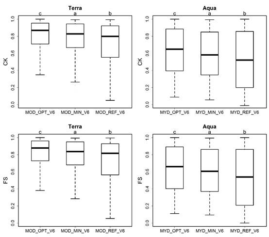
遥感积雪数据可以提供比有限的地面观测更广泛的积雪时空信息,而MODIS积雪产品是其中应用最为广泛的。该产品基于网格雪冰指数(NDSI)阈值法来判断积雪,即若NDSI值≥NDSI阈值则判定该网格为积雪覆盖。最近,NASA发布了MODIS积雪产品第6版(简称V6),以替代之前的V5版本。与V5相比,V6做出了一些重要更新,包括:(1)V6中的Aqua产品使用重建的波段6,而V5使用的是波段7来替代计算...
A COMPARATIVE ANALYSIS OF SPATIOTEMPORAL DATA FUSION MODELS FOR LANDSAT AND MODIS DATA
Surface Reflectance Remote Sensing Coleambally Landsat-like STI-FM
2018/5/14
In this study, three documented spatiotemporal data fusion models were applied to Landsat-7 and MODIS surface reflectance, and NDVI. The algorithms included the spatial and temporal adaptive reflectan...

蓝藻水华水体在近红外波段具有明显的植物特征“陡坡效应”,是卫星监测蓝藻水华的主要依据。水生植物拥有与蓝藻水华类似的光谱特征,在光学遥感影像上,基于近红外陡坡效应所研发的遥感监测方法,无法实现蓝藻水华和水生植物的同步监测。通常情况下,由于太湖水生植被主要分布在镇湖湾、光福湾、胥口湾、东太湖等区域 ,区别于水华易发区(太湖西部和北部),太湖蓝藻水华遥感监测通常将东太湖水生植被区进行掩膜处理,掩膜区不再...
PREDICTION OF CHANGES IN VEGETATION DISTRIBUTION UNDER CLIMATE CHANGE SCENARIOS USING MODIS DATASET
MODIS Beech Prediction modelling Climate change
2016/12/1
The distribution of vegetation is expected to change under the influence of climate change. This study utilizes vegetation maps derived from Terra/MODIS data to generate a model of current climate con...
RESPONSE OF RIPARIAN VEGETATION IN AUSTRALIA"S LARGEST RIVER BASIN TO INTER AND INTRA-ANNUAL CLIMATE VARIABILITY AND FLOODING AS QUANTIFIED WITH LANDSAT AND MODIS
riparian vegetation flooding river basin climate variability
2016/11/30
Australia is a continent subject to high rainfall variability, which has major influences on runoff and vegetation dynamics. However, the resulting spatial-temporal pattern of flooding and its influen...
A COMBINED APPROACH WITH SMOS AND MODIS TO MONITOR AGRICULTURAL DROUGHT
Agricultural drought MODIS SMOS soil moisture
2016/11/30
A synergistic fusion of the Soil Moisture and Ocean Salinity (SMOS) L2 soil moisture with the Moderate Resolution Imaging Spectroradiometer (MODIS)-derived land surface temperature (LST) and several w...
GLOBAL LAND COVER CLASSIFICATION USING MODIS SURFACE REFLECTANCE PROSUCTS
Global Land Cover Classification Algorithm Multi-temporal Multi-spectral Co-occurrence Matrix Non-Parametric Classifier
2016/11/23
The objective of this study is to develop high accuracy land cover classification algorithm for Global scale by using multi-temporal MODIS land reflectance products. In this study, time-domain co-occu...
APPLICATION OF THE TERRA MODIS SATELLITE DATA FOR ENVIRONMENTAL MONITORING IN WESTERN SIBERIA
Environment Satellite Images Geographic Information Systems Oil Fields
2016/11/15
Using the MODIS thematic products, the status of vegetation of oil producing areas in Western Siberia for the period 2010-2015 is monitored. An approach for estimating the impact of various factors on...
ESTIMATING PM2.5 IN THE BEIJING-TIANJIN-HEBEI REGION USING MODIS AOD PRODUCTS FROM 2014 TO 2015
Air Pollution PM2.5 MODIS Aerosol Optical Depth
2016/7/8
Fine particulate matter with a diameter less than 2.5 μm (PM2.5) has harmful impacts on regional climate, economic development and public health. The high PM2.5 concentrations in China’s urban areas a...
EVALUATION OF ANNUAL MODIS PTC DATA FOR DEFORESTATION AND FOREST DEGRADATION ANALYSIS
MODIS VCF Percent Tree Cover (PTC) deforestation
2016/7/8
Anthropogenic land-cover change, e.g. deforestation and forest degradation cause carbon emissions. To estimate deforestation and forest degradation, it is important to have reliable data on forest cov...
EVALUATION OF THE MAIN CEOS PSEUDO CALIBRATION SITES USING MODIS BRDF/ALBEDO PRODUCTS
Satellites Calibration Multi-Spectral BRDF/Albedo MODIS
2016/7/4
This work describes our findings about an evaluation of the stability and the consistency of twenty primary PICSs (Pseudo-Invariant Calibration Sites). We present an analysis of 13 years of 8-daily MO...
DUST STORM DETECTION BASED ON MODIS DATA
Dust Storm MODIS Satellite Remote Sensing (RS) Band Math Information Extraction Terra and Aqua
2016/3/17
Dust storm is a kind of meteorological disaster which usually takes place in the northern china in spring. It becomes a very important environmental issue and one of the major natural hazards. Its eno...
RETRIEVING LST AND ITS THERMAL ENVIRONMENT EVALUATION ANALYSIS BASED ON CBERS-02 IRMSS AND MODIS DATA
CBERS-02 IRMSS Land Surface Temperature (LST) Atmospheric Water Vapour Content Human Body Comfort Index Thermal Environment Evaluation
2016/3/17
The thermal environment and thermal effect is one of the most important contents in city climate and environment researches.Retrieving and analyzing land surface temperature (LST) is an efficient way ...